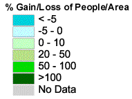
Percent Change in Population Density, by County, for Washington and Oregon 1850 - 2000
Data sources:
NTIS: Forstall, Richard L., Population of States and Counties of the United States: 1790 to 1990, U.S. Bureau of the Census, Washington, DC, 1996.
Discussion
HUSCO: The Historical United States County Boundary Files 1790 - 1999
Carville Earle, John Heppen, and Samuel Otterstrom Copyright 1991, 1996, 1999 Data Discussion
Software used:
Data preparation: Access
Map creation: ArcView 3.2a
Animation: Adobe Photoshop, QuickTime via QuickMovie
Steps:
I imported the NTIS population text files and the HUSCO .dbf files into Access, where I could compare and correct any discrepancies between county FIP codes and names. Then I joined the county and population data and exported to text files containing the current and prior year's population, state name, county name, and FIP code, one file for each year (1850, 1860, etc.).
In ArcView, I added these text files as tables and joined them to their corresponding HUSCO county shape file on the FIP field. I calculated the change in population density by
(current census population / county area)
---------------------------------------------------------
( last census population / county area)
to yield a percent change in the
The I applied a standard legend, and exported EPS files from Layout window for each year. The EPS files went through Adobe Photoshop to create BMP files, which are used in the animation. (This gives much less pixilated artwork than exporting BMP.)