back to County Voting Patterns in US Presidential Elections, 1976-2000
Go directly to main map
Manipulation in ArcView
We started by making a useful legend for the seven election results maps. We chose to display the data as unique values on the votecode field, so the winning party for each county would be displayed. These seven themes become the basis of all the subsequent analyses we performed. Click here to see the seven individual maps. (Scroll down for main map.)
Voting History
The first analysis resulted in a grid showing the number of times each county voted for each party in the seven elections. In order to represent this, we added the field partyValue to each theme's table based on the field voteCode. See Table 3 for the possible values.
Table 3
| voteCode value | partyValue result |
|---|
| D | 1 |
| R | -1 |
| I | 0 |
| N | 0 |
Query Builder was used to select, in turn, records with each of the four voteCode values. With those records selected, Map Calculator was used to populate the partyValue field.
With this new field in each theme, grids were created from each of the shapefiles. Click here to see the seven individual grid maps.
The partyValue fields for these seven grids were then added up with Map Calculator to produce the map below.
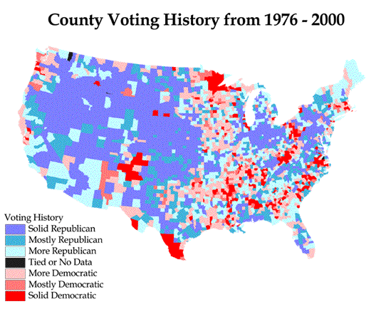
Possible values were -7 to 7, which we grouped as shown in Table 3a.
Table 3a
| Values | Label |
|---|
| -7 | Solid Republican |
| -4 to -6 | Mostly Republican |
| -1 to -3 | More Republican |
| 0 | Tied or No Data |
| 1 to 3 | More Democratic |
| 4 to 6 | Mostly Democratic |
| 7 | Solid Democratic |